In the first days of the Armenian-Azerbaijani clashes that started on July 12, 2020 near Berd (former Shamshadin) in Tavush region, rumors spread that the Armenian side had occupied the Azerbaijani post(s).
This news was neither officially confirmed nor denied. Again rumors spread that the Armenian side had captured a strategic position of the opponent. On July 17, the representative of the Ministry of Defense Artsrun Hovhannisyan announced during a press conference that neither the Armenian nor the Azerbaijani armed forces had captured a strategic position. He did not say anything definite about capturing a stronghold position.
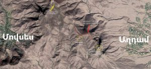
On July 14, the independent research website Nagorno Karabakh Observer located the stronghold position from which the Armenian side made the already famous footage of the Azerbaijani UAZ vehicle. According to the website, that position is located between the Azerbaijani villageAghdam and Armenian village Movses.
And already on July 16, when the Ministry of Defense published the footage and photos depicting how the bodies of Azerbaijani soldiers were being removed by their fellow servicemen, the Nagorno Karabakh Observer mentioned that the stronghold position in that area was taken under control by the Armenian side.
The stronghold is located on a hill known as Gharadash or Sevakar. It was named “Fearless” by the RA Ministry of Defense, and it is located in the following geographical coordinates: 40.904468, 45.527870.

The Fact Investigation Platform tried to find out in which country’s internationally recognized borders this new (“Fearless”) position is within.
In general, the de facto Armenian-Azerbaijani border in Tavush region differs significantly in some parts from the de jure recognized borders.
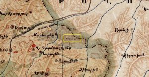
According to the map of Soviet Armenia made by Khachatur Avdalbegyan in 1932, the Armenia-Azerbaijan border in the section near Movses village passes through the peak of Karabash or Karabakh, which is the same as the Gharadash plateau.

In Google Earth and Google Maps programs, the Armenian-Azerbaijani state border is roughly marked (but mostly very close to the map) and mostly passes over the hills.
It is clearly seen here that the “Fearless” position taken under control by the Armenian side is in the territory of Armenia.
The position is located on the south-western side of the mountain range, thus, it is in the territory of the former Soviet Armenia, the borders of which are considered to be the internationally recognized borders of the Republic of Armenia.
Moreover, this position, furnished by the Azerbaijani army in the territory of Armenia, posed significant danger for the civilian population of the Armenian village of Movses, which was presumably an additional motivation for the Armenian army to take that position under control.

Meanwhile, the position left on the Gharadash hill under the Azerbaijani control is right on the border.
With the control of the new position, the Armenian side significantly hampered the effective use of the Gharadash position by Azerbaijan, as the road leading to it was completely under the control of the Armenian armed forces.
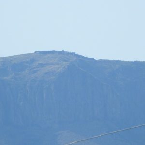
This rather large position of Azerbaijan is depicted in the photo.
The state border runs directly in the middle of that position. In other words, even a half of that position is in the territory of Armenia.
Why is this important?
The fact that the new strategic position is actually in the territory of Armenia is especially important in the context of the political positions of third countries.
Thus, during the clashes in Tavush, the Ministries of Foreign Affairs of Moldova and Ukraine issued statements in support of the territorial integrity of Azerbaijan, whereas the clashes took place in the territory of Armenia. It is Azerbaijan that has built positions in the Berd region in the territory of Armenia. This is also evident in the following map prepared by PAN.am.
Hovhannes Nazaretyan

 FACTOMETER


