ԻՐԱԶԵԿ ՔԱՂԱՔԱՑԻՆԵՐԻ ՄԻԱՎՈՐՈՒՄ•UNION OF INFORMED CITIZENS•СОЮЗ ИНФОРМИРОВАННЫХ ГРАЖДАН
Fact Investigation Platform
Նվիրաբերել
ՏԵՂԵԿԱՑՆԵԼ ԿԵՂԾԻՔԻ ՄԱՍԻՆ
Donate
REPORT DISINFORMATION
Поддержать
СООБЩИТЬ О ДЕЗИНФОРМАЦИИ
  • FACTOMETER
    • FALSE
    • MOSTLY FALSE
    • WITHOUT VERDICT
    • MOSTLY TRUE
    • TRUE
    • FAKE
    • MANIPULATIVE
  • Investigative
  • Data journalism
  • Explainer
  • VIdeos
  • All
  • enen
    • Русский (ru)ру
    • Հայերեն (hy)հյ
Արդյունքներ չեն գտնվել
Դիտել բոլոր արդյունքները
FIP.AM
  • FACTOMETER
    • FALSE
    • MOSTLY FALSE
    • WITHOUT VERDICT
    • MOSTLY TRUE
    • TRUE
    • FAKE
    • MANIPULATIVE
  • Investigative
  • Data journalism
  • Explainer
  • VIdeos
  • All
  • enen
    • Русский (ru)ру
    • Հայերեն (hy)հյ
Արդյունքներ չեն գտնվել
Դիտել բոլոր արդյունքները
ԻՐԱԶԵԿՔԱՂԱՔԱՑԻՆԵՐԻՄԻԱՎՈՐՈՒՄ
FIP.AM
Արդյունքներ չեն գտնվել
Դիտել բոլոր արդյունքները
Donate
Home Investigative

Google Maps and General Staff maps of 1976 match in the areas subject to delimitation in Tavush

19:35, 22 Apr, 2024

On April 19, the Ministry of Foreign Affairs of the Republic of Armenia issued a statement on the regular meeting of the commissions on border security and delimitation of the state border between Azerbaijan and the Republic of Armenia, held on the same day.

Accordingly, the parties agreed to start the process “immediately between settlements in Baghanis (Arm) – Baghanis Ayrum (Az), Voskepar (Arm) – Ashagh Askipara (Az), Kirants (Arm) – Kheirumli (Az) and Berkaber (Arm) – Kizil Hajili (Az) in order to align it with the legally substantiated inter-state border existing at the time of the collapse of the Soviet Union. 

According to the statement of the Ministry of Foreign Affairs, the process should be agreed and signed between the parties by May 15, 2024.

On the same day, the Prime Minister’s Office provided “Armenpress” agency with a number of details regarding the first stage of the border delimitation process in Tavush and a map expressing the agreements reached between Yerevan and Baku.
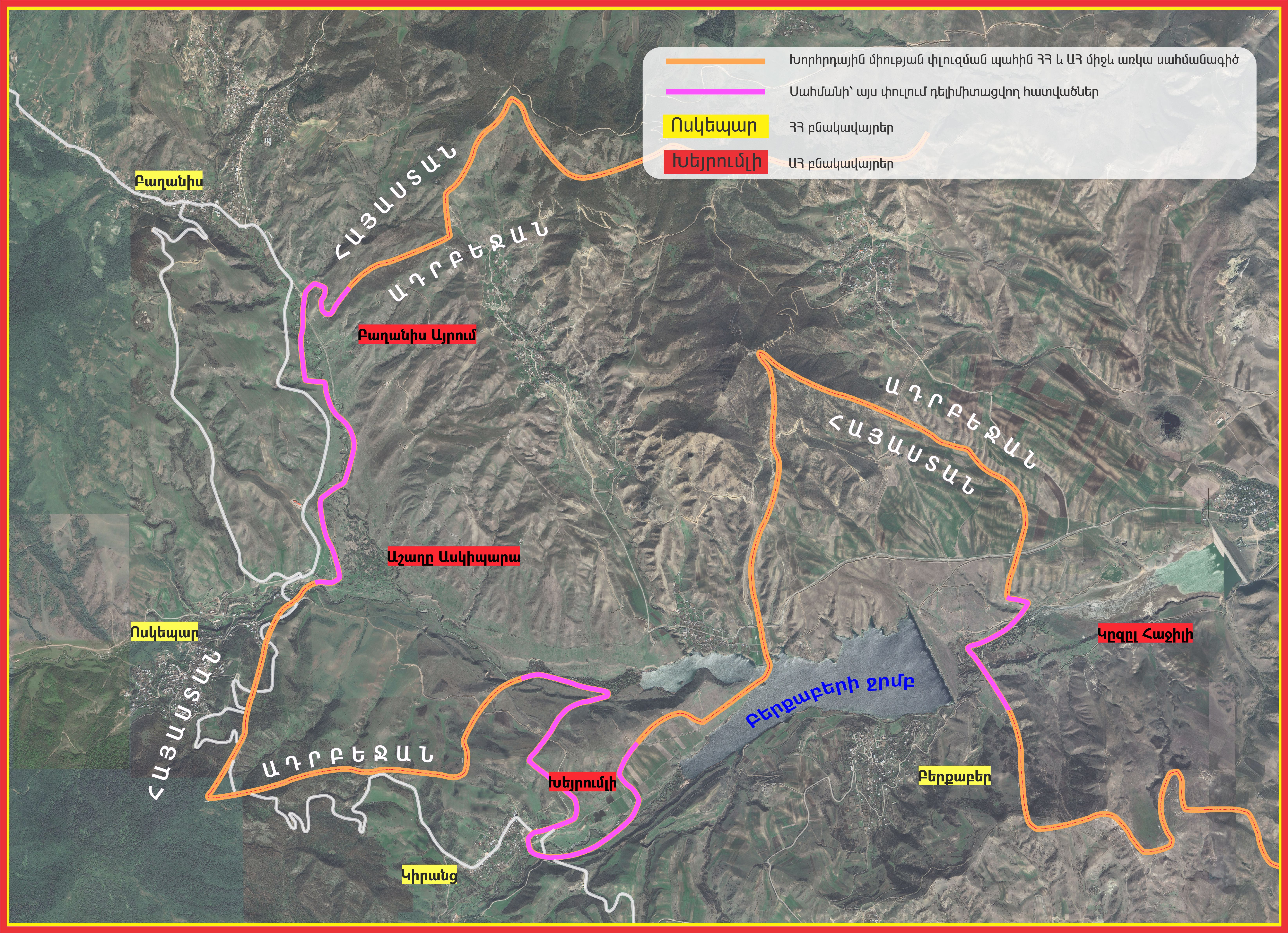
Map provided by the Prime Minister’s Office

Earlier, the Armenian leadership had repeatedly announced that the process would be carried out based on the map of the 1970s. In an interview to Radio Liberty in May 2023, Armenian Prime Minister Nikol Pashinyan stated: “We say that we are ready to accept the entire border as of the maps of 1975.”

While in January 2024, Armenian Minister of Foreign Affairs Ararat Mirzoyan stated that the border between Armenia and Azerbaijan should be delimitated on the basis of official maps with strong legal foundations developed by the competent authorities of the Soviet Union. “You know that we have always talked about the maps of 1974-1978 as the most recent maps reflecting the principles I mentioned. It is noteworthy that there was a proposal to use maps of 1974-1990, that proposal was from the Azerbaijani side.” 

Fact Investigation Platform studied the topographical maps of the areas to be delimitated in Tavush region developed by the General Staff of the Soviet Union’s Armed Forces from the 1970s, available in open sources, and compared the Armenian-Azerbaijani border reflected there with the borders reflected on Google Maps.

According to the Satmaps.info online resource, the borders of the settlements in question in Tavush region are reflected on the map K38-103/91 of 1976 of the USSR General Staff.

The map shows the administrative border between Soviet Armenia and Azerbaijan in black dotted lines, roads in a dark red line, and rivers in blue.
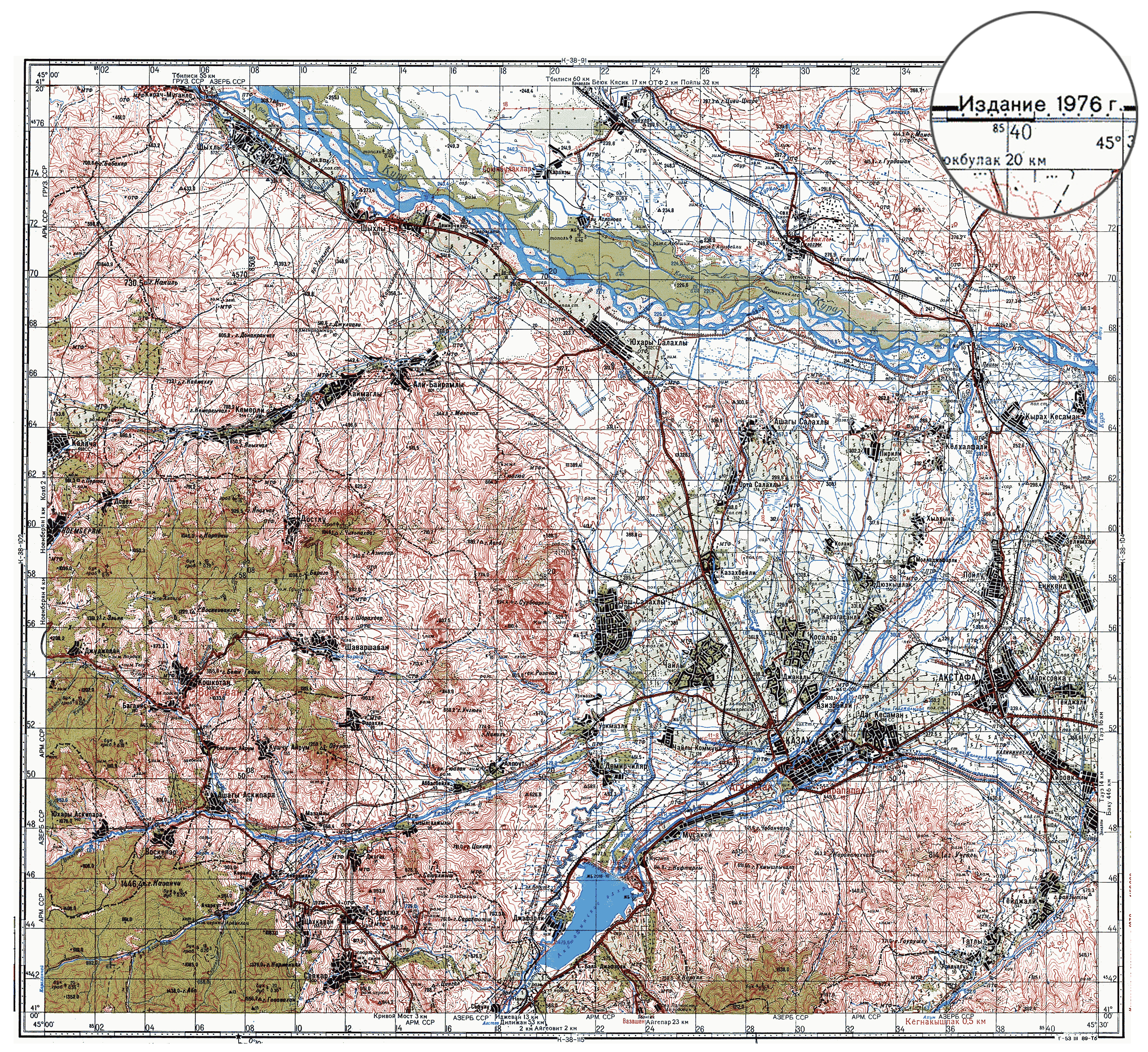
FIP.am has made the administrative border line between Armenia and Azerbaijan on the General Staff map expressive in red, highlighting the Armenian and Azerbaijani settlements subject to delimitation.
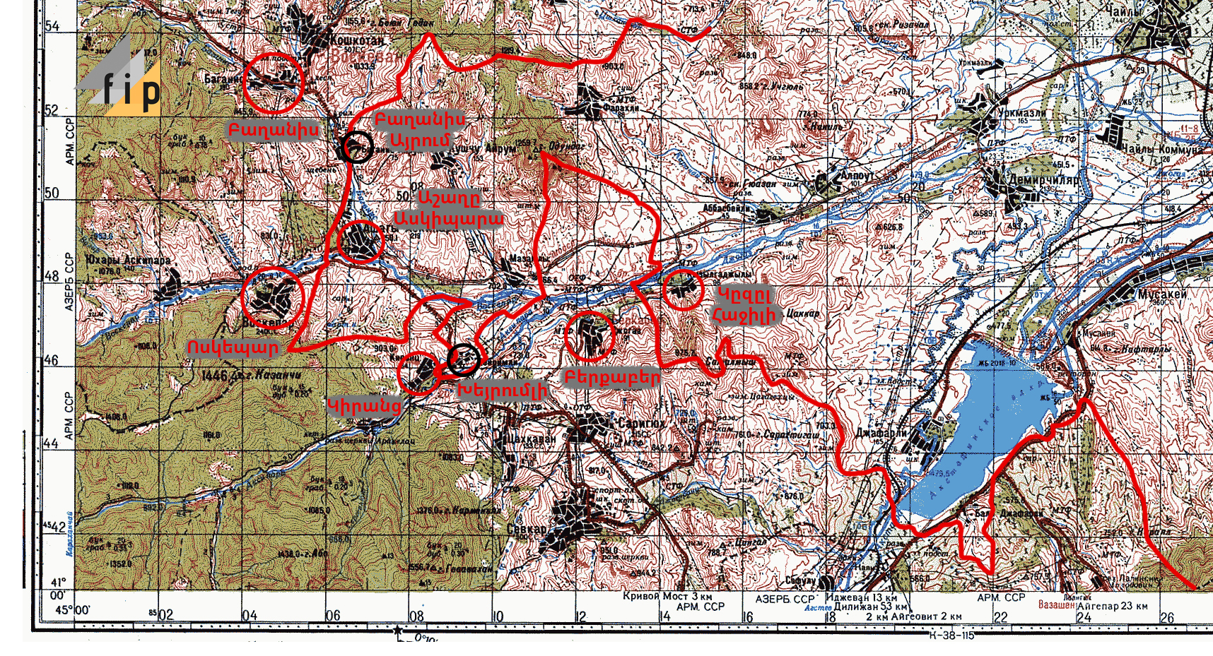
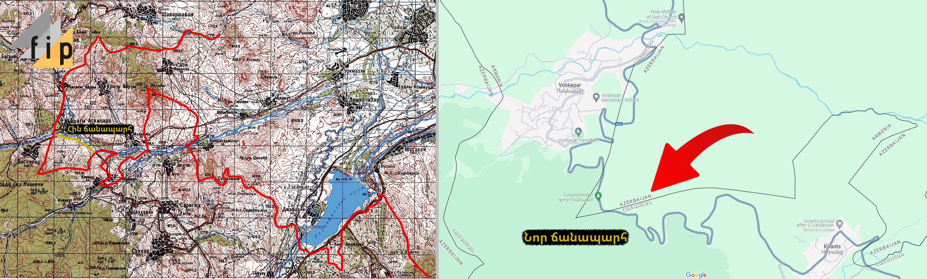
A study of the border line in the relevant areas on Google Maps shows that it matches with the borders reflected on the Soviet Union General Staff map of 1976.

The comparison of Google Maps and General Staff maps also makes it clear that the road leading to Voskepar has been changed. While in the 70s it ran parallel to the river bed, now it has moved 1-2 kilometers to the southwest.
The Berkaber reservoir, which is currently occupied by Azerbaijan, is not on the General Staff map either. The reservoir was commissioned in 1980. It is now reflected on Google Maps.
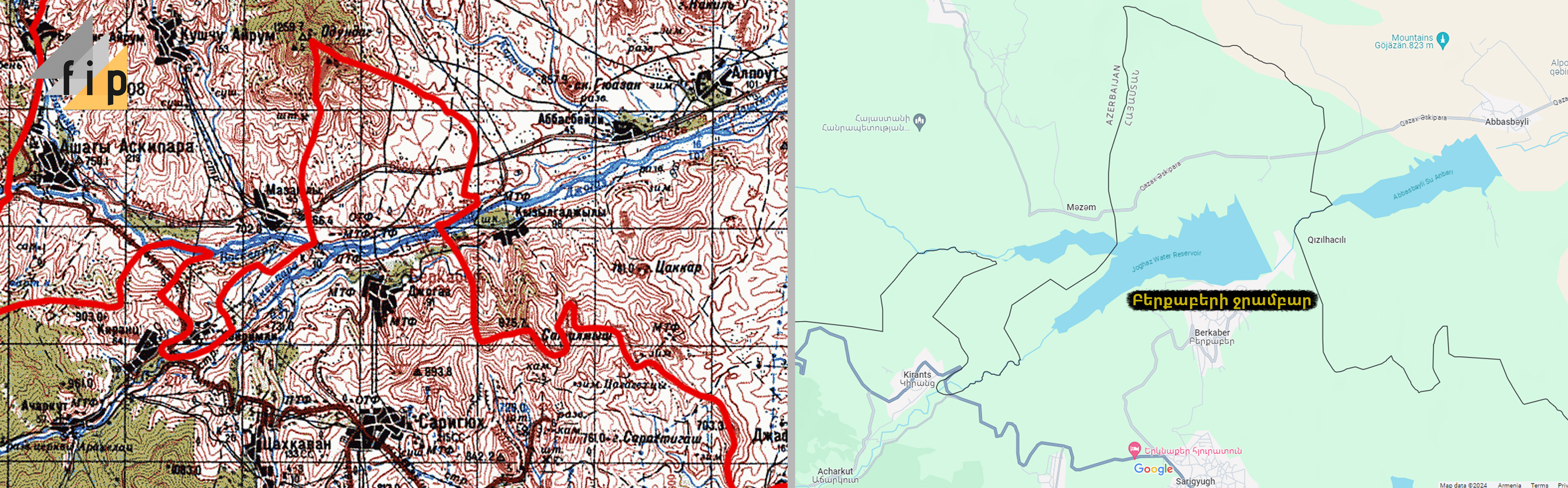
Thus, the Armenian-Azerbaijani borders reflected on Google Maps subject to delimitation in Tavush, match with the General Staff map of 1976 of the administrative borders of Soviet Armenia and Azerbaijan in the areas in question.

Nane Manasyan

  • Total: 0
  • 0
  • 0

Related Articles

Maps of missing persons and graves: What evidence reveals regarding the statement made in Warsaw
Investigative

Maps of missing persons and graves: What evidence reveals regarding the statement made in Warsaw

11:13, 6 Oct, 2026

At the OSCE Warsaw Human Dimension Conference, which opened on October 5 in Warsaw, Nazrin Aliyeva, a member of Azerbaijan’s...

Iran’s historical flag emoji not MFA spokesperson’s choice: X changed it
Manipulative

Iran’s historical flag emoji not MFA spokesperson’s choice: X changed it

16:11, 4 Oct, 2026

Armenian National Assembly “Strong Armenia” faction MP Arega Hovsepyan referred on Facebook to an X (formerly Twitter) post by Ani...

From border to consumer: How is Russian gas price formed for Armenian consumers?
Explainer

From border to consumer: How is Russian gas price formed for Armenian consumers?

11:59, 24 Sep, 2026

The border price of natural gas supplied from Russia to Armenia and the tariff paid by consumers differ substantially. This...

Withdrawal of Russian Border Guards Would Not “Nullify” the Armenia–Turkey Border: Edgar Ghazaryan’s False Claim
False

Withdrawal of Russian Border Guards Would Not “Nullify” the Armenia–Turkey Border: Edgar Ghazaryan’s False Claim

13:46, 15 Sep, 2026

Edgar Ghazaryan, an MP from the National Assembly’s “Strong Armenia” faction, made several false and problematic claims concerning the Armenia–Turkey...

Related Articles

Maps of missing persons and graves: What evidence reveals regarding the statement made in Warsaw
Investigative

Maps of missing persons and graves: What evidence reveals regarding the statement made in Warsaw

11:13, 6 Oct, 2026

At the OSCE Warsaw Human Dimension Conference, which opened on October 5 in Warsaw, Nazrin Aliyeva, a member of Azerbaijan’s...

Iran’s historical flag emoji not MFA spokesperson’s choice: X changed it
Manipulative

Iran’s historical flag emoji not MFA spokesperson’s choice: X changed it

16:11, 4 Oct, 2026

Armenian National Assembly “Strong Armenia” faction MP Arega Hovsepyan referred on Facebook to an X (formerly Twitter) post by Ani...

From border to consumer: How is Russian gas price formed for Armenian consumers?
Explainer

From border to consumer: How is Russian gas price formed for Armenian consumers?

11:59, 24 Sep, 2026

The border price of natural gas supplied from Russia to Armenia and the tariff paid by consumers differ substantially. This...

Withdrawal of Russian Border Guards Would Not “Nullify” the Armenia–Turkey Border: Edgar Ghazaryan’s False Claim
False

Withdrawal of Russian Border Guards Would Not “Nullify” the Armenia–Turkey Border: Edgar Ghazaryan’s False Claim

13:46, 15 Sep, 2026

Edgar Ghazaryan, an MP from the National Assembly’s “Strong Armenia” faction, made several false and problematic claims concerning the Armenia–Turkey...

FIP.AM

  • About Us
  • Methodology
  • Corrections and Complaints policy
  • Contact us

Partners

Membership

IFCN Signatory Badge


Copyright © 2025 Union of Informed Citizens

Արդյունքներ չեն գտնվել
Դիտել բոլոր արդյունքները
  • FACTOMETER
    • FALSE
    • MOSTLY FALSE
    • WITHOUT VERDICT
    • MOSTLY TRUE
    • TRUE
    • FAKE
    • MANIPULATIVE
  • Investigative
  • Data journalism
  • Explainer
  • VIdeos
  • All
  • Հայերեն (hy)
  • English (en)
  • Русский (ru)

Copyright © 2025 Union of Informed Citizens